Te Kuiti - Raglan - TeKuiti
Login or Join Adventure Guide for full access to the Adventure Map, plus information including detailed route notes, fuel stops, food supplies/dining, accommodation, preparation and safety, downloadable GPX files plus a printable booklet.
Route Overview
General Overview
This Adventure was created and personally logged by Ross Bowden. Ross is a keen adventure rider with an extensive knowledge of the remote North Island track network.
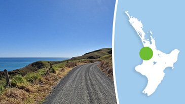
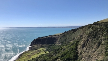
The Te Kuiti - Raglan - Te Kuiti loop is a day trip that includes some of the best public gravel roads in the area.
These include awesome sections through: Waipuna, Hauturu, Raglan, Kawhia, Whaanga, and Old Mountain Roads.
This Adventure is best traveled in good weather as the views on a clear day are superb.
Start/Finish Point
This is a loop trip.
The GPX files and route information supplied for this Adventure start and finish at Te Kuiti. It can be traveled in either direction.
Terrain includes
Awesome windy tarmac roads, great metal roads, fantastic scenery.
All the gravel roads included in this route are Grade 1 in dry conditions.
Distance
269 km.
Max Fuel Leg
81 km into the Leg you will reach Oparau, where there is fuel available at: Oparau Roadhouse and General Store.
157 km into the Leg you will reach Raglan where there is fuel available at:
BP
2 Main road Raglan
Travel Time
Average seat time is 5.25 hours at a steady pace, allowing plenty of time to have a good look around some of the interesting places.
Access Permission
All roads within this Adventure are publicly accessible so access permission is not required.
Access Limitations
This Adventure is recommended for fine weather. While it is possible to travel this route all year round, if there has been recent heavy rain there can be slippery, muddy sections.
Safety
While this is not considered a technical route it does include a few semi-remote areas so it is recommended to travel as a group with typical equipment including tools, spares and a PLB or emergency beacon.