Banks Island
Login or Join Adventure Guide for full access to the Adventure Map, plus information including detailed route notes, fuel stops, food supplies/dining, accommodation, preparation and safety, downloadable GPX files plus a printable booklet.
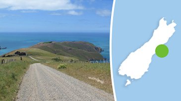
Route Overview
General Overview
The Banks Island Adventure utilises the best gravel roads possible to circumnavigate Banks Peninsula, in a full day trip. It is a great option to soak up the best sights and gravel tracks that the Peninsula has on offer.
Why the name Banks Island? Captain Cook of the Endeavour who mapped New Zealand did a remarkably accurate job however Banks Island was one of two mistakes made in his mapping. Cook thought this land mass was an island and named it "Banks Island" after the Endeavour's onboard botanist named Joseph Banks.
The mistake was not realised until 1809, when Captain S. Chase of the Pegasus tried to sail between the island and the mainland and couldn't! The island was reclassified as a peninsula, and renamed Banks Peninsula.
Start/Finish Point
Starts from Halswell, then ends in Cashmere.
Terrain includes
The terrain includes the least amount of tarmac, with as many interesting gravel roads as possible. The majority of the gravel roads are Grade 1 and Grade 2.
Note: On Leg 1, there is one small 100 meter Grade 3 section of loose gravel to cross the Lake Forsyth Causeway Bridge. The difficulty of this section will vary depending on the changing conditions, and the vehicle you use. If you prefer to keep the entire Adventure to a maximum of Grade 2, then Leg 1 offers a detour around this loose gravel section.
Distance
Total distane is 235 km
Max Fuel Leg
135 km
Travel Time
Due to the volume of winding gravel terrain, the travel time for both Leg 1 and Leg 2 of this Adventure is around 5 to 6 hours.
Taking into account stopping at lookouts, having a bite to eat etc ideally you'll want to plan around a whole day, and set off early.
Access Permission
All routes within this Adventure are on publicly accessible roads/tracks so access permission is not required.
Access Limitations
This Adventure can be travelled in any season, but it is highly recommended to do it on a clear blue sky day with good visibility. The sights along this route are outstanding, so it is a shame to have them limited by low cloud, or fog. Planning around pockets of good weather will make all the difference.
Photos