G2G
Login or Join Adventure Guide for full access to the Adventure Map, plus information including detailed route notes, fuel stops, food supplies/dining, accommodation, preparation and safety, downloadable GPX files plus a printable booklet.
Route Overview
General Overview
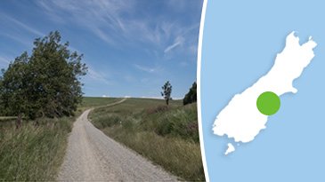
The G2G is a 450 kilometre Adventure made up of the best gravel back roads starting from Geraldine, and looping back to Geraldine.
If you like taking your time, soaking in the sights, and snapping photos along the way, then this route lends itself to be done over two days. However, if you enjoy a faster paced adventure full of winding gravel roads, then this makes an excellent full day route.
Start/Finish Point
While this Adventure can be started at any point along the way, it has been structured to start and end in Geraldine.
Terrain includes
While some tarmac is necessary to link up all the gravel roads, the majority of this Adventure are Grade 1 and Grade 2 gravel roads.
Spread throughout the route are around half a dozen small fords, however at normal flow rates they are no more than 1 foot deep, and pose no challenge.
Distance
450 km total distance.
Max Fuel Leg
The maximum distance between fuel stops is 205 km on Leg 2.
Travel Time
This Adventure was logged on an adventure bike, so the travel times are for a motorbike being ridden at a steady pace. If you prefer a slower pace, are with a large group, or in a 4X4 vehicle, you may want to add some extra time to the recommendations below.
The route is made up of two legs and can be done as a single day, or over two days:
Option 1 (Single day) : Combining both Leg 1 and Leg 2 provides a full day with a conservative travel time of around 8 hours.
Option 2 (Two days) : Splitting Leg 1 and Leg 2 over two days for a more relaxed paced, has travel times of around 4 hours for Leg 1, and around 4 hours for Leg 2.
Accommodation
If you choose the two day option, there are a few accommodation suggestions inducing camping, cabins, motels or a B&B in the details of Leg 1.
Access Permission
All roads within this Adventure are publicly accessible, so access permission is not required.
Access Limitations
This Adventure is ideally suited to fine weather. While it is generally possible all year round, it is common for snow to occur in winter, and close one of the key high altitude passes. This presents a bit of an anticlimax as the detour to bypass the high altitude passes will remove some of the highlights. Ideally, this route is best in late Spring, Summer, and Autumn, and at periods where no seasonal/unseasonal snow has fallen.
If there has been recent heavy rain, then a day or two should be waited before setting off as the small and shallow fords can become deep, rushy, and unfordable.
Safety
While this is not considered a technical route, it does include a few semi-remote areas. For this reason it is recommended to carry tools and spares for any trail side repairs, and carry an emergency beacon or satellite tracking device.
Videos