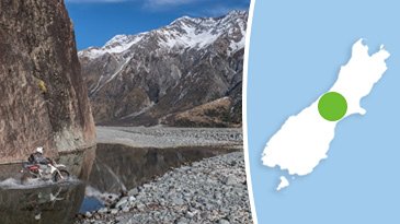
Triple Valley
Login or Join Adventure Guide for full access to the Adventure Map, plus information including detailed route notes, fuel stops, food supplies/dining, accommodation, preparation and safety, downloadable GPX files plus a printable booklet.
Route Overview
General Overview
The Triple Valley Adventure has been designed for the serious adventurer looking for the ultimate High Country valley route. It offers three days of exceptional High Country terrain that will have any keen adventurer fizzing.
The name Triple Valley is based on the route covering three High Country valleys. It is graded as a challenge as the the upper stretches of each valley can be quite challenging.
The vistas throughout the route are nothing short of spectacular, offering brilliant photo opportunities at every turn.
This Adventure route has been ridden, logged and assembled on an adventure bike. However, it is also the perfect adventure route for well-setup 4X4 vehicles. Whatever vehicle you choose, the experience will not disappoint!
If you are on an adventure bike, the lighter the bike, the better. While you can do this route on a larger bike (and it has been done) you must be willing to put in a lot of effort wrestling your bike over some fairly rocky terrain, and some decent river crossings.
Start/Finish Point
This Adventure is structured to start at Mt Somers, then finish in Geraldine. The way it is structured means it can be an adventure all on its own, or, you can connect it to a route you are looking to extend.
The start/finish locations can be reversed if you prefer, however all the information provided for each Leg will be travelling from Mt Somers to Geraldine (north to south).
Terrain includes
The start and tail end of this route include Tarmac and Grade 1 gravel roads however the majority of this route is Grade 3 and Grade 4 with some sections of Grade 5.
There are many sections of well-formed, flowing, 4X4 tracks. The 4X4 tracks have many sections that are regularly washed out by floods leaving stony or bouldery riverbed sections, plus gravel scree terrain. This will test your ability to pick good lines through boulder fields!
Throughout the route there are multiple stream crossings, and approximately half a dozen medium to large river crossings. One of the rivers to cross is very bouldery, and will require good river crossing skills.
Distance
249 km
Max Fuel Leg
249 km
Travel Time
This route has been designed to do over three days. This provides a full day to make your way through each Leg, day plus sufficient time to set up camp and enjoy the High Country experience at the end of each day.
Accommodation
The two nights of accommodation can either be spent in High Country huts, or camping. Accommodation information is provided in each Leg.
Access Permission
This route passes through a small section of a private High Country station and requires permission. Permission is readily granted with advance notice. The contact information and the best process to seek permission is provided in the details of Leg 1.
Access Limitations
While each season will vary, generally the best times to ride this Adventure are the months of February, March, April and May. This period offers the lowest river levels, and the best chance for successful crossings.
Around spring and early summer, high levels of snowmelt can raise the rivers to dangerous and impassable levels.
Mid-winter to late winter will often bring regular rain and snowfall, regularly making the rivers impassable, and blanketing the valley floor in snow.
Safety
THIS IS NOT AN EASY ADVENTURE!
This is designed for experienced adventurers that are well-setup for challenging terrain, have a comprehensive toolkit, spares, and a good general mechanical knowledge to perform trail-side repairs if need be.
While this Adventure does pass a number of huts that can be used for accommodation, in the case they are full, you'll need a quality 3 or 4 season tent, sleeping bag, and camping gear. You'll need the ability to carry extra food in case you get caught on the wrong side of a rising river, plus an emergency beacon or satellite tracking device.
It is important to have sound understanding of the risks that come with entering the remote the High Country.
Temperatures will vary based on the season you choose to do this Adventure. Late summer temperatures will often be mild through the day, however it is possible for overnight temperatures to reach zero. In winter, overnight temperatures will often be below 0 degrees Celsius, with heavy frosts being commonplace.
Unscheduled storms and poor weather can hit the High Country in ANY season bringing rain and snow. This can trap you up river valleys so carrying surplus food for three additional days is essential to allow high river levels to recede before you can return. Planning around good weather is essential for a successful and safe trip.
While the route is only 249 km the majority is slow going technical terrain and results in heavy fuel consumption. Make sure you carry extra fuel just in case you use more than expected.
While it is possible to do this Adventure solo, it is recommended to do it in a group for safety.